| |
TRANSDAT (English) 16.01
|
|
| |
Short Description:
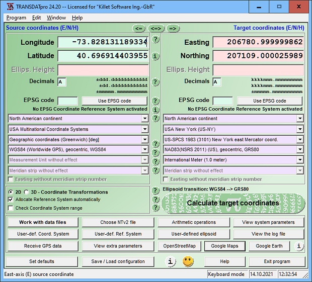
TRANSDAT Coordinate conversion and datum shift with highest accuracy
|
| Last Updated: 1/20/2013 | File Size: 2548 KB | Price: $190 | Downloads: 663 | Developer:
C. Killet Software Ing.-GbR |
| OS: WinME,WinNT 3.x,WinNT 4.x,Windows2000,WinXP,Windows2003,Wind... |
| TRANSDAT (English) 16.01
Description: |
| TRANSDAT geosoftware executes coordinate transformations and geodetic datum shifts between many coordinate and reference systems of America, Australasia, Europe, Germany special and world-wide, with high precision and high speed: 1.The current and historical coordinate and reference systems of all countries of the European Union (EU) including the eastern extensions and the systems of non-EU countries. 2. The INSPIRE supported European ETRS89 systems. 3. The US and Canadian State Plane Coordinate Systems (SPCS) on NAD27 and NAD83 and other coordinate systems of the North American continent. 4. The coordinate and reference systems of the Australasian continent. 5. Many coordinate and reference systems of the countries of other continents. 6. World-wide NTv2 grid file supported coordinate transformations. 7. All global coordinate and reference systems. 8. The German coordinate and reference systems of the old and new federal states, the 40 Prussian Soldner Land Registers, the German Lagestatus, and exact reference systems of the German federal states. You will find a complete list of the coordinate and reference systems supported by the program on the web or after downloading the free test version of the program. The NTv2 standard with national grid files is world-wide full supported. Apart from the given world-wide and state-specific systems, your own personal coordinate systems and geodetic reference systems can be defined with Helmert (Bursa / Wolf, ISO 19111) or Molodensky parameters. Calculations can be performed with coordinates entered directly, loaded from files in various formats (Text, CSV, SDF, dBase, KML, ArcShape, ArcGenerate), or passed by batch processing. ArcShape files can be viewed with the internal Shape Viewer. A programmable GPS interface makes it possible to read coordinates from a low-cost GPS antenna. The program can be run on a network, in which case clients are installed automatically. The program has a multilingual interface. |
| TRANSDAT (English) 16.01
Free Download |
|
|
|
|
| |
|
|
| |
Most downloaded software in category: »
|
|
| |
|
|
| |
Last updated software in category: »
|
|
| |
|
|
|
|
Statement: First, please download the orginal installation package by clicking the download link. Of course you may also download it from the publisher's website. Using TRANSDAT (English) crack, key, patch, serial number, registration code, keygen is illegal. The download file hosted at publisher website. We do not provide any download link points to Rapidshare, Hotfile, Depositfiles, Mediafire, Filefactory, etc. or obtained from file sharing programs such as Limewire, Kazaa, Imesh, Ares, BearShare, BitTorrent, WinMX etc. Software piracy is theft. If you like TRANSDAT (English) please buy it.
|
|

 (Click to enlarge)